SUBTERRANEA
Underground landscapes
Mining shaped large parts of the landscape of the Euregio Meuse-Rhine. The slagheaps of Liège and Genk (BE), the Rhenish mining area (DE) and the Mijnstreek (NL), for example, are visible on the horizon far beyond the borders. The yellowish limestone gives its name to the Mergelland and is the material of a special architecture, as in Valkenburg (NL) or around the Sint-Pietersberg (BE-NL). The unique Viola calaminaria on the acidic soils containing heavy metals in Kelmis, Plombières (BE) and Stolberg (DE) attract numerous visitors across the borders in spring.
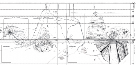
The map "SUBTERRANEA" draws a subjective picture of this extraordinary post-mining landscape without borders: a mirror of the underground in the above-ground structure.
Looking at the map we take the point of view of hikers crossing the Three-Countries Park: along a cross-section from the limestone area of the Sint-Pietersberg to the former zinc and lead mines of Plombières and Kelmis (Neutral-Moresnet) near the Three-Countries Point and on to Hambach with its massive open-cast lignite mine, the full range of the region's mining history becomes visible, with its various manifestations and peculiarities. Three field books with travel reports on the three stages that led to the creation of this map accompany and complement the map.
This project of a somewhat unusual mapping of the mining heritage deepens the "Subterranea" line of the DearLandscape project, which - on the occasion of the European Landscape Convention - explored how residents and visitors perceive and value the landscape.
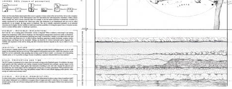
With this in mind, the "layers of perception" at the bottom of the map pick up on various recurring themes that the two Dear Hunter cartopologists encountered during their journey through the region: for example, the visibility of some industrial sites (such as waste rock piles or open pit mines) contrasts with numerous structures that have disappeared or are invisible from the surface (such as the mining galleries or sites built over with industries). The intertwining of nature and industry is also addressed: many an area once polluted by overburden is now among the most important nature reserves in the region, such as the "site minier" near Plombières.
This extraordinary natural and cultural heritage is not only evidence of a mining history that is interwoven across borders. The "underground landscape" still provides a cross-border identity today and, in view of global resource crises, is once again gaining (sometimes controversial) topicality. Therefore, the Three-Countries Park co-organized a Living Lab on the sustainable development of the post-mining landscape, where the Subterranea map offered numerous ideas for discussion. The map can also be seen at the 3LP booth at the Three Countries Festival on the theme "The Euregio from below".


Duration: 2021-2022
Financing: Three-Countries Park
Three-Countries Park: project development, support and assistance
Study office: Dear Hunter
More information: facebook.com/thisisdearhunter
Downloads:
SUBTERRANEA - Fieldbook 1 (Kanne - Maastricht - Eben-Emael)
SUBTERRANEA - Fieldbook 2 (Vaals - Kelmis - Plombières)
SUBTERRANEA - Fieldbook 3 (Hambach - Inden)
Did you know that...
... the underground passages and caves of the Sint Pietersberg served as a military hospital, bunker and hiding place for art treasures, such as Rembrandt's Night Watch, during the German occupation (1940-1944)?
... in the 19th century the roofs of Paris were covered with zinc from Kelmis and that the last inhabitant of Neutral-Moresnet did not die until 2021?
... that the Sophienhöhe is the highest artificial mountain in the world (302 m above sea level) - and that the bottom of the open cast Hambach lignite mine right next to it is the lowest point in Europe (299 m below sea level)?


